


With growth comes growing pains. That certainly goes for cities. They need proper infrastructure to support their growing populations. So much so, that approximately $2.6 trillion dollars is required annually through 2030 to scale the level of sustainable infrastructure required. Not just to support population growth, but also economic expansion in developing countries, and to renew existing infrastructures, that will make them more resilient to climate change.
Hong Kong is home to many construction marvels. Its urban landscape is a testament to human ingenuity and ambition. However, beneath the surface lies a complex challenge that we must address: ensuring the sustainable growth of Hong Kong, given its scarce land availability, which it is mainly solving through land reclamation and restoring brownfield sites and rural land to developable land. All this infrastructure requires geo-data to support its development and maintenance, and protect its surroundings and the wider natural environment. Significantly, acquiring geo-data will be key to mitigating the sub-surface risks associated with those activities and controls.

William Fung, Director, Land Site Characterisation,
Fugro Hong Kong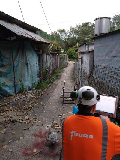
Non Intrusive Site Screening
Expanding Hong Kong territories through land reclamation and restoration
To accommodate the expanding population and meet economic development needs, the government has embarked on two ambitious plans — the Northern Metropolis development and the reclamation of artificial islands in the central waters. These plans involve land reclamation and repurposing of idle farmland, fishponds, and brownfield sites.
Within the realm of land formation and transformation, understanding the Earth’s foundation is crucial for sustainable construction. Many of the construction risks associated with these projects lie beneath the surface. Effectively characterising the spatial and behavioural variability of the subsurface geology is essential for managing subsurface risks successfully. In the absence of sufficient, robust, qualifying ground data, developers could end up over-engineering or under-engineering an asset, and both could cost them more money.
In particular, land reclamation has been a common way for Hong Kong to expand its territory to meet the needs of a growing urban population with its coastal surroundings. However, a major concern regarding reclamation is land subsidence, as land is often built by dumping filling materials onto marine sediments that are usually compressible before any ground improvement works are applied. This poses additional difficulty on top of the various complexity of underlying geological conditions that are unique to different parts of HK. This is where geo-data plays a key role in providing comprehensive and integrated insights to mitigate geological risks and economic losses.
Predictive wisdom goes a long way
In the industry, the possession of quality geo-data is the closest thing to being clairvoyant. Information about ground conditions can provide builders and developers with valuable analytical powers, to avoid catastrophic economic and social outcomes.
A wealth of vital geodata is required to address engineering design challenges throughout the project lifecycle. Traditionally, the process involved desk studies and site reconnaissance, followed by intrusive drilling to reveal unseen ground conditions. However, given the disruptive nature of borehole drilling, there has been a shift towards geophysics-based site screenings to enhance preliminary investigations.
Such screenings involve non-intrusive surveys that acquire geo-data to develop an extensive ground model. Site screening enables better location planning for subsequent intrusive investigations, confirming stratigraphy and providing engineering design parameters for subsurface materials. This can then be followed by an optimised conventional investigation. The lead to less time, less cost, a smaller carbon footprint and reduced exposure to operational risks for field staff for the resulting site characterisation works to determine the subsurface conditions and the soil composition. With the construction industry facing a prevailing shortage of labour and equipment, such screenings can address the shortfalls without compromising on data accuracy and integrity.
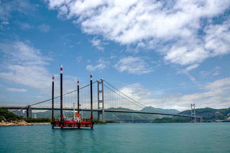
Marine Site Characterisation Campaign 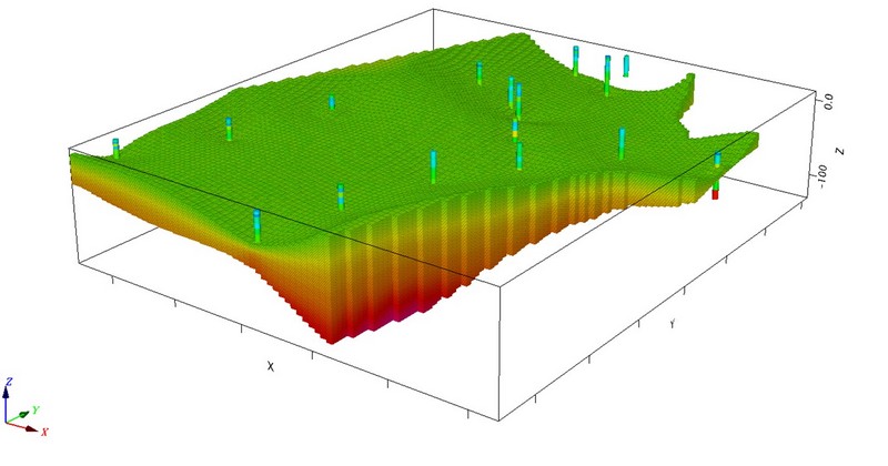
3D Ground Modeling
The evolution of geo-data analytics
The latest integrated site characterisation solutions go beyond the provision of high-quality geo-data through field services alone. These solutions incorporate geophysics in the initial site screening, refine the geo-data laterally, acquire quality data through drilling and laboratory testing, and enhance the data with instrumentation monitoring for construction control and post-construction health and safety. It allows developers to understand the ground situation before investing in labour-intensive work of drilling rigs and large borehole programmes, equipping them and other stakeholders with an invaluable tool for improving safety and minimising risk throughout the whole asset lifecycle.
My years in the industry have also shown that quality software solutions are the backbone of a robust data ecosystem, capable of collecting and analysing substantial project data. Land site characterisation surveys depend largely on mapping out the underlying geology where buildings are constructed. Through advanced 3D ground modelling, it is possible to pinpoint problem areas for ground risks to confidently target intrusive techniques. By adopting this approach, it also reduces the risks commonly associated with physical data collection, which can be time-consuming and sometimes unsafe for geoscientists and engineers alike. Additionally, the reduction in drilling rigs and boreholes saves cost and time, while cutting the carbon footprint, and improving site safety management supporting faster design decisions. In conclusion, ensuring quality geo-data is critical for the overall success of civil engineering projects, and it hinges on site characterisation that ensures the safety, sustainability, cost effectiveness of the design and construction of the projects. The integration of geophysics, drilling, laboratory testing, and monitoring provides a comprehensive understanding of subsurface conditions, reducing risks associated with ground conditions. By leveraging geo-data through site characterisation works, this in turn enables Hong Kong to build structures that will withstand the test of time. The pursuit of sustainable construction is not only a response to current needs, but a commitment to building a resilient future, where the built environment harmonises with the social, economic, and environmental aspirations of Hong Kong.